Space Technology: Playing the Role of Earth’s Protector
Space Technology: Playing the Role of Earth’s Protector
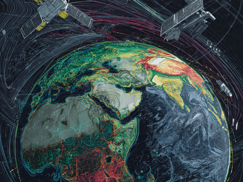
Today, the satellites orbiting our Earth are not limited to weather forecasting. This cutting-edge space technology is constantly monitoring the health of our Earth like a protector. These satellites tell us the Earth’s vital signs, just like a doctor checks the pulse of a patient. When the sea level rises, these satellites tell us immediately. When the polar ice melts, they keep a record of it. When forests are cut down, they confirm it. This space technology is actually writing a diary of the Earth’s health, and is blessing us with data that was never available before. A recent NASA mission has discovered that changes in Earth’s atmospheric patterns are happening much faster than we expected. Satellites from the European Space Agency have shown that the behavior of ocean currents is changing in unexpected ways. All this data is important for scientists, governments, and ordinary citizens alike, because it helps us make decisions about the future of the Earth. Space technology has given us a new way to understand systemic changes in the Earth, which are acting as warning signs for us.
In the past, we had only limited data about the health of the Earth, but now space technology has given us a global perspective. This technology tells us how changes in the Amazon rainforest affect the temperature of the Arctic region. It teaches us how dust storms in the African deserts fuel hurricanes in the Atlantic Ocean. This interconnectedness gives us an understanding of Earth system science that was not possible before. Without space satellites, we would never have been able to understand the complex patterns of climate change. This technology allows us to see that our Earth is a living, breathing system, with all its parts interconnected.
Thanks to space technology, we can now not only detect problems, but also find solutions. For example, with the help of satellite data, we can determine which agricultural practices can improve carbon sequestration. We can identify which forest areas are most important for conservation. We can predict which coastal cities will be most affected by sea level rise. All this information helps us make evidence-based decisions.
Today, space technology has democratized environmental monitoring. Small countries, research institutions, and even ordinary citizens can access satellite data. This global transparency is leading us to collective action. When all countries have the same data, it becomes easier to ensure the implementation of international agreements.
Space technology will become even more advanced in the future. We will see real-time monitoring systems that will be able to detect environmental changes immediately. We will see predictive models that will be able to tell us ten years in advance which regions will experience water scarcity. We will see early warning systems that will alert us before natural disasters.
Space technology is indeed proving to be a blessing to our planet. It is providing us with the tools we need to understand and protect Earth’s complex systems. As this technology advances, our capabilities will also improve.
◉ Monitoring Climate Change: The Eyes of Space
Space technology is proving to be our most powerful weapon in the fight against climate change. State-of-the-art satellites are collecting detailed data on Earth’s atmosphere that has been available for the first time in human history. These satellites not only measure atmospheric carbon dioxide levels, but also detect leakage points of methane gas. NASA’s OCO-2 satellite has discovered that the Amazon rainforest is now becoming a carbon source rather than a carbon sink. Satellites from the European Space Agency’s Copernicus programme have shown that the temperature increase in the Arctic region is three times the global average. These data are not just numbers; they tell us about the metabolic changes on Earth.
Space technology has helped us understand how the Earth’s carbon cycle works and how human activities are affecting it. This data is also helping to verify climate models, which is increasing the accuracy of our predictions. Through satellites, we can also see how effective different mitigation strategies are. For example, satellite data has shown that the European Union’s emissions trading system has significantly reduced greenhouse gas emissions.
Furthermore, space technology has helped us understand climate feedback mechanisms. We now know how the melting of Arctic permafrost is releasing additional methane into the atmosphere. We understand how forest fires are depleting carbon stores. These intricate relationships help us understand the complexity of the climate system.
Satellite monitoring has also taught us that the effects of climate change are not uniform globally. Some regions are warming more rapidly than others. Some areas are experiencing more dramatic changes in precipitation patterns. These regional variations help us develop targeted adaptation strategies.
Thanks to space technology, we can now better assess the economic impacts of climate change. We can calculate how much damage will be done to coastal infrastructure by sea level rise. We can estimate how changing rainfall patterns will affect agriculture. This economic data helps policy makers make informed decisions.
Going forward, space technology will also help us with carbon accounting. We will be able to precisely measure how much carbon each country is absorbing and releasing. This transparent monitoring system will make international climate agreements more effective.
◉ Natural Disaster Prediction: Life-Saving Technology
Space technology has revolutionized disaster management. State-of-the-art satellites can now observe the formation patterns of hurricanes and typhoons in such detail that we can accurately predict their path and intensity weeks in advance. Japan’s Himawari-8 satellite takes a complete image of the Pacific Ocean every 10 minutes, giving meteorologists real-time data. NASA’s GPM Core Observatory satellite provides precipitation data so accurate that flood predictions have been achieved with an accuracy of up to 80%.
Space technology is also opening new paths in earthquake prediction. The European Space Agency’s SWARM satellites have discovered that changes in the Earth’s magnetic field occur before major earthquakes. All these advances are not only saving lives but also reducing economic losses.
Satellite data has also brought us a revolution in disaster risk assessment. We can now identify which areas are most vulnerable to floods, landslides, or storm surges. This information is helping with urban planning and infrastructure development. We can implement protective measures in high-risk areas.
Space technology has also brought significant improvements in post-disaster response. Satellite imagery helps rescue teams make a quick assessment of damaged areas. It helps estimate the size of the affected population. It also helps survey damaged infrastructure.
Satellite data is also proving valuable in the disaster recovery phase. We can monitor how reconstruction efforts are progressing. We can assess how ecosystems are recovering. This is helping with long-term recovery planning.
Early warning systems have shown particularly remarkable results. In Bangladesh, cyclone warnings have reduced casualty rates by up to 100 times. Tsunami warning systems in the Pacific islands have saved countless lives. These success stories show how effective space technology can be.
In the future, we will see integrated disaster management systems that combine multiple data sources. These systems will use predictive analytics and generate automated alerts. This advancement will take disaster resilience to new heights.
◉ Water Resources Management: Protecting the Basis of Life
Space technology is proving to be a game changer in water resources management. NASA’s GRACE-FO mission is observing changes in groundwater storage, which is providing early warnings of water scarcity. ESA’s SMOS satellite is providing soil moisture data, which is helping in agricultural water management. This data is not only helping in drought prediction but is also proving to be helpful in water allocation decisions.
Observation of river flow patterns has also helped in resolving transboundary water disputes. Satellite-based monitoring has made it possible to increase irrigation efficiency by up to 30%. All these advances are playing an important role in improving water security.
Space technology has also played a significant role in water quality monitoring. We can detect which lakes are affected by algal blooms. We can monitor what pollution levels are in coastal waters. This information is proving to be helpful in water treatment and conservation efforts.
Satellites have also revolutionized glacier monitoring. We can measure how fast Himalayan glaciers are melting. We can track how polar ice sheets are changing. This data is extremely valuable for long-term water resource planning.
Space technology is also finding applications in urban water management. We can identify where water distribution systems in cities are inefficient. We can detect where underground water leaks are occurring. These insights are helping in water conservation.
In the future, we will see real-time water resource management systems. These systems will integrate satellite data and make automated water allocation decisions. This advancement will play a significant role in ensuring water security.
◉ Transformation in Agriculture: A New Era of Farming
Space technology has taken precision agriculture to new heights. Modern satellites are revolutionizing the health monitoring of crops. Planet Labs satellites provide daily high-resolution imagery, helping farmers monitor crops in detail. This data enables early detection of nitrogen levels, water stress, and disease outbreaks.
ESA’s Sentinel-2 satellites have shown that crop yield predictions can be made with an accuracy of up to 95%. These advances are not only increasing food production but also increasing resource efficiency. Satellite-guided farming has made it possible to reduce the use of chemical fertilizers by up to 20%.
Space technology has also brought about changes in the field of crop insurance. Insurance companies now use satellite data to make an objective assessment of crop damage. This system reduces fraudulent claims and speeds up claim processing.
Satellites have also played an important role in food security monitoring. International organizations such as the UN’s FAO use satellite data to assess global food production. This information is helpful in the allocation of food aid.
Space technology is also proving helpful in promoting sustainable agriculture. We can identify which agricultural practices are the most environmentally friendly. We can monitor how conservation efforts are working. These insights are encouraging the adoption of sustainable farming.
In the future, we will see autonomous farming systems that integrate satellite data. These systems will make real-time decisions and perform automated actions. This advancement will maximize agricultural productivity.
◉ Global Environmental Strategy: Data-driven Decision-Making
Space technology has transformed global environmental governance. Satellite data has now become a standard tool for monitoring compliance with international environmental agreements. Satellite data is being used to verify emissions reductions by countries under the Paris Agreement. Progress monitoring of the UN’s Sustainable Development Goals also relies on space data.
This data improves transparency and accountability. The Global Forest Watch initiative has made deforestation monitoring possible through satellite data. This system provides real-time alerts, which helps prevent illegal logging.
Space technology has also played an important role in the field of environmental justice. We can identify which communities are most affected by pollution. We can track how environmental hazards are distributed. This information is helpful in the design of equitable policies.
Satellite data is also being used in monitoring corporate environmental responsibility. Investors now use satellite imagery to assess the environmental performance of companies. This transparency encourages sustainable business practices.
Space technology has also played a significant role in promoting international cooperation. Shared satellite data has increased trust between countries. This cooperation is proving helpful in solving global environmental challenges.
In the future, we will see integrated global environmental monitoring systems. These systems will provide real-time data and perform automated compliance verification. This advancement will make global environmental governance more effective.
◉ Preparing for the Future: New Technologies
The future of space technology looks even brighter. The joint NASA-ISRO NISAR mission will launch in 2024, which will observe millimeter-level changes in the Earth’s surface. ESA’s Biomass satellite will conduct the first comprehensive survey of global forest biomass. Private companies such as SpaceX and Blue Origin have reduced the costs of earth observation, which has increased the accessibility of data.
The integration of AI and machine learning has made satellite data analysis more effective. All these developments will help us better understand the Earth’s changing environment. They will help us better understand the effects of climate change. They will provide us with the tools we need for a sustainable future.
New sensor technologies have increased observational capabilities. Hyper spectral imaging allows us to perform detailed chemical analysis of the Earth’s surface. Synthetic Aperture Radar allows us to see beyond cloud cover. These technologies are expanding our monitoring capabilities.
The small satellite revolution has also democratized Earth observation. CubeSats and other small satellites have reduced the costs of data collection. This development allows smaller countries and private companies to participate in Earth observation.
Remarkable advances are also being made in the field of data processing. Cloud computing has made it possible to analyze massive satellite datasets. AI algorithms have automated pattern recognition. These advances are providing us with faster and more accurate insights.
In the future, we will see integrated Earth observation systems that combine multiple data sources. These systems will provide comprehensive environmental monitoring. This advancement will transform our planetary stewardship capabilities.
◉ Global Cooperation: Saving the Earth Together
Space technology has taken global cooperation to new heights. Earth observation experiments are being conducted on the International Space Station. The World Meteorological Organisation’s global weather data sharing system is working. The Group on Earth Observations (GEO) brings together more than 100 countries and organisations that share earth observation data.
This cooperation is not only advancing scientific research but is also helping in global policy making. This international collaboration is our greatest strength in the fight against climate change.
Space technology has also played an important role in the field of capacity building. Technical assistance is being provided to developing countries so that they can use satellite data. This empowerment is improving global equity.
Joint missions have further strengthened international cooperation. NASA-ISRO’s NISAR mission is demonstrating the power of international partnership. ESA’s Copernicus programme is the result of cooperation between multiple countries. These collaborations are proving to be helpful in achieving shared goals.
Knowledge sharing platforms have also promoted global cooperation. International conferences, workshops, and training programs have made the exchange of expertise possible. This intellectual cooperation is accelerating innovation.
In the future, we will see more integrated global networks. These networks will make real-time data sharing possible. This advancement will make global environmental monitoring more comprehensive.
◉ Conclusion: The Role of Earth’s Custodian
Space technology is indeed playing the role of the Earth’s custodian. It is providing us with the data and insights we need to understand the earth’s changing climate. It is helping us to deal with natural disasters. It is making global environmental governance effective.
Without space technology, the fight against climate change would have been almost impossible. But thanks to this technology, we have hope, we have knowledge, and we have the capability to take action. This role will become even more important in the future.
We have seen how space technology has transformed our environmental monitoring capabilities. We have seen how it has revolutionised disaster management. We have seen how it has strengthened global cooperation.
In the future, as this technology advances, our planetary stewardship capabilities will also improve. We will be able to do more effective environmental protection. We will be able to make more accurate predictions. We will be able to implement more sustainable policies.
Space technology is giving us the opportunity to understand and protect Earth’s complex systems. This opportunity is helping us become responsible planetary citizens. This transformation is making a better future possible for our future generations.